


The Bureau of Reclamation actually bought the 17 square miles needed for this project from the Navajo Tribe...this was part of their reservation.


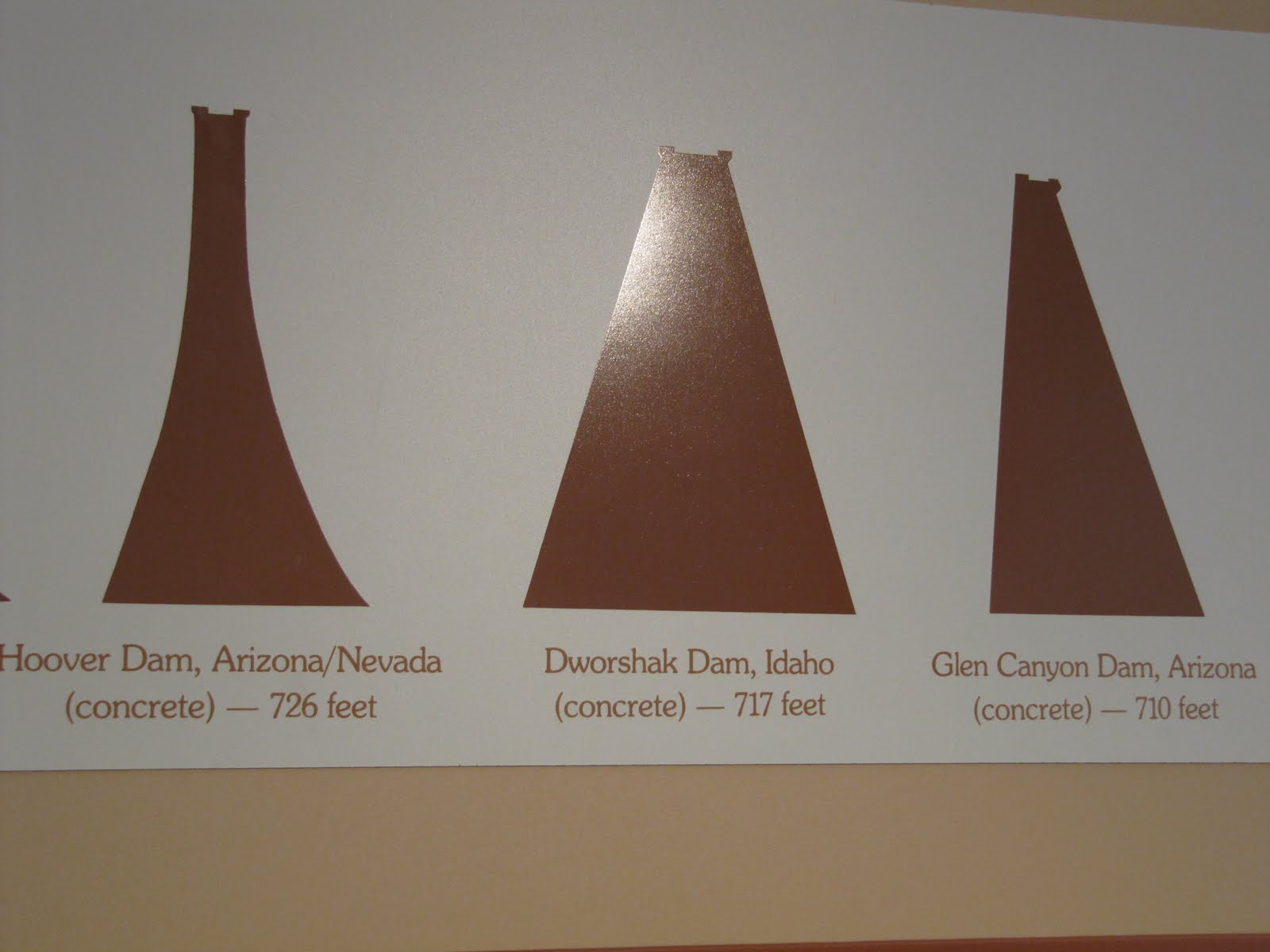
This shows that this dam is the 3rd largest concrete dam in the country. It was finished in Mar 1963, but didn't finish filling completely until Jun 1980.

This is the Carl Hayden Visitor Center, named after a long-serving U.S. Senator, and the Glen Canyon Bridge. The bridge is 700 ft above the river, and almost 1300 ft across the canyon. Barb, you definitely wouldn't like this bridge...when we were walking across it you could feel it bouncing as the cars passed!


Info on dinosaur tracks outside the Visitor Center.


Some stitch pics of the Lake Powell area above the dam. Lake Powell is the largest man-made lake in the country...186 miles long, with almost 2000 miles of coastline.


Riding up the road to see a little more of the National Recreation Area and Lake Powell, Cathy said she thought she saw an overlook area as we were driving into the area yesterday. So we took a right off the highway up this seemingly boring road, and then enjoyed a panoramic view of the area. I would love to own a boat in this area!


Cathy took the last 2 pics above with the cell phone...not bad, huh?
Once again just beautiful. Cathy's pictures are awesome. But the picture above them with the clouds is unbelievable.
ReplyDeleteIt took me a few minutes to figure out it was a cloud. First I thought it was some kind of tunnel.
does anyone rent boats on that lake? what about fishing? I would not want to ride across that bridge. love ya
ReplyDeleteWOW Paula,
ReplyDeleteThe pictures keep getting better and better.
Ellen, I didn't know the picture was a cloud at first either. I thought if was a big wave or water swirling.
Great picture.
Ellen, I thought it was a tunnel for planes to fly through as a short cut to Nevada! haha It's funny that you and Fifi both commented on it...I posted it because I loved how the clouds looked, but I never thought it would confuse anyone. haha
ReplyDeleteEleanor, we don't know about fishing, but we are going to take a boat tour on the lake over the next few days.
My favorite pic is the very first one. Cathy on top of that rock looking like she's contemplating what a good life you have.
ReplyDeleteThe dam took 17 yrs to fill??? Waiting for rain water???
The colors in the sky with the clouds really adds to the pics.
Don't like the sound of the bridge. I would have been sooo nervous you guys would have been laughing at me.
I'd love to be in a boat right now with you guys!!!!!!!!!!
Paula, I also like the rocks with the layers/ridges that you are sitting on. Kind of reminds me of my thighs. I always said they were as "solid as a rock" now I have a picture to prove it.
ReplyDeleteVery interesting cloud wave. Also resembles a tornado funnel. Lucky for you and Cathy it wasn't. God knows where fluffy would have ended up.
Sad to say I lost my dollar on the number so don't expect any million dollar split.
Look forward to the next day trip.
First, I would have had to get on the bridge to feel the cars going across. As I said, guess the only way I will ever see any of these things is if I can find a non-bridge/tunnel way, or I will never get to.
ReplyDelete