12 September 2010

Glen Canyon Dam & Rec Area

12 Sep 2010--Went to see the Glen Canyon Dam and a little of its National Recreation Area today, starting from an area called Scenic View Drive right up the street from where we are staying. You have to climb down into this rocky area and then you can see up to the dam and down into the canyon. Every time I see rocks like these I am mesmerized by them...I just love all the layers in them.


The Bureau of Reclamation actually bought the 17 square miles needed for this project from the Navajo Tribe...this was part of their reservation.


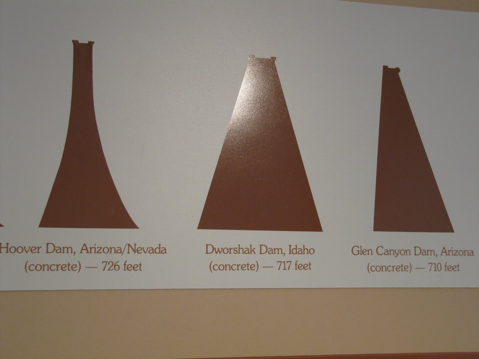
This shows that this dam is the 3rd largest concrete dam in the country. It was finished in Mar 1963, but didn't finish filling completely until Jun 1980.


This is the Carl Hayden Visitor Center, named after a long-serving U.S. Senator, and the Glen Canyon Bridge. The bridge is 700 ft above the river, and almost 1300 ft across the canyon. Barb, you definitely wouldn't like this bridge...when we were walking across it you could feel it bouncing as the cars passed!

Info on dinosaur tracks outside the Visitor Center.
Some stitch pics of the Lake Powell area above the dam. Lake Powell is the largest man-made lake in the country...186 miles long, with almost 2000 miles of coastline.


Riding up the road to see a little more of the National Recreation Area and Lake Powell, Cathy said she thought she saw an overlook area as we were driving into the area yesterday. So we took a right off the highway up this seemingly boring road, and then enjoyed a panoramic view of the area. I would love to own a boat in this area!


Cathy took the last 2 pics above with the cell phone...not bad, huh?

11 September 2010

On To Arizona

11 Sep 2010--Left Utah today after a total of about 6 weeks. Just wanted to go on the record that we totally loved being there, and will miss the startling beauty of it!

Headed southeast today, mostly east to Page, Az, which is located in the north central part of the state, only a few miles from the Utah border. Just a few pics of the drive.


We will be in Page for a week, still trying to figure out where we are going tomorrow and beyond. I like both the state flag and the license plates.


Right beyond the "Welcome to Arizona" sign were our first views of Arizona. A little hazy due to the smog...there is something about these smokestacks against the beautiful background that is much more depressing than if we had seen it in a big city.


This is the campground we are in, and a view of Lake Powell right up the street from us. We will be taking a boat cruise of the Lake Powell area, we just don't know which day yet.

P.S. Arizona is one of maybe 2 states (Indiana?) that doesn't change time zones during the course of the year, so we are now 3 hours behind Boston time, and 2 hours behind San Antonio. Stay tuned!

10 September 2010

It Was Bound To Happen

10 Sep 2010--Went to Zion National Park yesterday, and unfortunately were very disappointed in our trip. Cathy read somewhere that Zion is the most visited nat'l park in Utah, but after being there, we can't figure out how that is. Our only guess is that because it is situated only 4 miles from the Arizona border, a lot of people must come from there into Utah to see it.


Driving into the park, we were very hopeful. Once you go past the entrance station, and for the next 10 miles to the Visitor Center, there are spectacular views. There is road construction the entire way, but that has been the case in every park we have been to all summer, so we were cool with that. The thing that stands out here is that the mountainside seems to be on top of you, and you go from one type of massive rock formation to another. You can't get panoramic views of most of it because you can't stop along the side of the road (due to the construction), and then again it is right on top of you, so you can't back up far enough to get a good shot. Look at the difference in these rock formations.


We had to drive thru 2 tunnels, the longest of which was a one lane drive for 1.1 miles thru the heart of a mountain...with no lights inside. The 2nd picture here shows how deep in the mountain you are (see the hole in the center) and the 3rd pic shows a cutout in the mountain that lets some light in as you drive through. I could easily have freaked out in here...I was feeling quite claustrophobic...so I had to consciously not think about where I was.


Here are some more pics as we drive to the Visitor Center


Once we got to the Visitor Center our hopes were dashed! We had no choice but to park our car and get on a tour bus to see the rest of the park...they started this practice back in the year 2000 because the crowds were getting so big.
These 2 buses are actually attached, the front one dragging the back one along for the ride. Being on a bus was bad enough, but being on the back bus was ridiculous. Other than seeing left or right out the window, depending on what side you were sitting on, your only other option was to look thru the ceiling windows...how absurd!
Here we are trying to get pics out the side windows, and Cathy stretching to get pics thru the ceiling windows. The side windows only opened about 8"...see my hand!
Cathy did get this pretty shot thru the ceiling, with the cell phone.
Like other parks, there are stops along the way where you can get off the bus to see some sights, but unlike the other parks we have been to there wasn't a lot to see in the immediate area. For the most part you stood at the bus stop and took your pics, then waited for the next bus to come by to go to the next stop.
At this 1st stop we observed what they called the Court of the Patriarchs...the mountains across from the parking lot. As you look at the stitch pic left to right, these mountain tops are named Abraham Peak, Isaac Peak, Mount Moroni (the Mormon angel), and Jacob Peak. Oh well!!!
At the last stop we got off and decided to take a hike along a path they had blocked off. The problem here is that whenever you see pictures of this park in a brochure, all the beautiful pics shown are after you have hiked about 16 miles into the bowels of the park. Needless to say, Cathy and I weren't going anywhere near 16 miles, so after about a mile we turned around and got back on the bus to go back to the Visitor Center.
The entrance fee to this park is $25, so basically everyone is taking a $25 bus ride...not worth it at all. I can truly say that if this had been my 1st visit to a nat'l park, it surely would have been my last. What should have been a spectacular visit, based on the entrance, turned out to be a prolonged bus ride...very disappointing!
On a lighter note, I have suffered a couple minor injuries lately. I cut a chunk of skin out of my finger while cutting Cathy's hair, and the day before that I cut my leg at the North Rim of the Grand Canyon.

Luckily, we had purchased this medical kit before we left San Antonio in May, so we were well prepared for any accidents!!!